A Hillfort and Toxic Dump.
Had an informative and enjoyable morning drinking coffee and talking with the Rev. Paul Cawthorne in Shrewsbury this week. Sitting overlooking the River Severn and hearing of his remarkable works campaigning vigorously for various serious pollutions that need to be firstly accepted, and then resolved. He gives a remarkable energy to his campaigning method; nothing appears to put him off from his quests.
One site that Paul introduced us to being remarkable in so many ways and makes one thankful that times have changed (one hopes) in so many ways is the toxic waste disposal facility that operated within an ancient monument right into the 1970s and even beyond as a council waste tip.
What appears as fantastical is that it has been an important Ancient Monument, registered first in the 1920s, but in the 1950s the site was, after a short archaeological exploration used initially as a gravel quarry. The gravels being set above the flood plain of the River Lugg. The gravels being of only a few metres in depth. The site was in part excavated in the late 1940s prior to the site’s internal destruction.

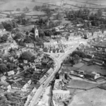
Once the gravel was removed a further 2 metres of ground was removed, and household waste was deposited in the void bottom. This was followed by cell development and deposition of liquid wastes from a varied group of industries. (As seen in the aerial photographs.) In the early 1970s the site was banned from taking further liquid waste and returned to receiving household waste. This state of affairs continued for several years until the site reached the agreed elevation agreed with the County Council prior to waste disposal starting on site. The site was capped and abandoned in 1979.
The various government departments who have been responsible for the care of this historic site have become increasingly concerned for its future, along with the local authority and the Environment Agency: the latter two for reasons of public health and pollution of local water supplies and environmental harm to the River Lugg, a tributary of the River Wye.
The local Authority do not wish to or have been requested not to gain the site a Section II (A) status as contaminated land as it would require actions that would require securely fencing this important historic site and barring public access.
Such action would receive widespread condemnation of the council and the Environment Agency. A report on the site and its state of contamination has been published but is now redacted. Borehole detail has also been withheld from the public domain.


Photograph of the site from the air taken around 1970, the site is plainly visible and divided into cells with liquid fill. What appear to be tankers or holding


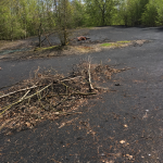
The surface of the waste site is capped by a half metre of ‘hoggin’, clay marl which has in part sunk into the fill, both toxic liquid and household/industrial solid waste. The cap is not apparently sound as the photographs above demonstrate. The site has sunk allowing pipes and other larger items to protrude from the surface.

The plan above shows a ring of boreholes surrounding the hillfort site. Sadly, the information gained by the borings is confidential to those who commissioned the research: said to be the local authority and Environment Agency

There is a need for information which has been paid for from public funds to be available so that a true understanding of the situation might be gained. The local authority, Environment Agency or other government department is not protecting this fort as an official secret of the state. It is easier to find details of Royal Naval ships and shore establishments than to inquire into such a site. The public are not fools and those that hold the information need to understand as much.

The bedrock geology of the site. (BGS). The superficial deposits overlaying the site were preglacial gravels.
References.