Antalya is the 5th largest city in Turkey and the country’s fastest growing. It is the economic centre of the tourist area known as the Turkish Riviera. It is located in a semi-arid location with approximately 37cm annual precipitation.

Geology.
The geological area of the city itself is fairly straightforward being made up of Tufa (a porous rock composed of calcium carbonate and formed by precipitation from water) limestone which has left the Antalya plain a remarkable example of a karstic landscape. Rivers that flow over the surface are usually flowing in greater volume below.
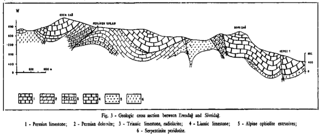
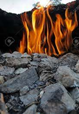
The mountains to the west are more complex with both heavily faulted karst limestones and Ophiolitic intrusions, alongside significant signs of seabed vulcanisation during Permian period. The area being unique in Turkey for having a series of methane springs that have constantly burnt for more than 2500 years at Yanartaş.
This phenomenon was reported on in ancient texts and today, noted by natural gas researchers in their politically controversial borehole explorations in the eastern Mediterranean Sea.
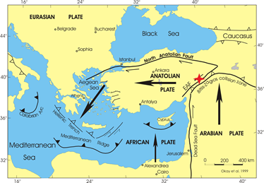
The geology is though much more benign in this part of Turkey being not prone to severe earthquakes though these events are often felt in the area. The country is situated on an insular Anatolian plate along with part of Greece, set between three jostling continental tectonic plates: the Arabian, African and Eurasian. The Arabian plate is actively turning Turkey slowly in an anticlockwise direction hinging on the Caucasus mountain chain. This excess pressure, plus that of the African plate in the past forcing up the Taurus mountains that stretch from the east though to the west of the country. The most unstable and earthquake prone areas of Turkey may be visualised as an inverted horseshoe traveling from the south easterly then curving towards the west just inland from the Black Sea coastal belt and then turning south towards Izmir and Marmara.

The limestones though karstic give a solid foundation across the city of Antalya, its spreading urban shadow that is swallowing up large areas of what was its agricultural hinterland. Though much fruit farming continues alongside a huge areas of glass house produced salad crops.

Surface Waters.
Duden Stream and Aksu River.
Düdenbaşı Waterfall karstic system.
At the 28th and 30th kilometre markers (17 and 19 miles) of the old route from Antalya to Burdur (which goes through Döşemealtı town), two karstic upwe[[ings appear. These water sources, Kırkgözler and Pınarbaşı, merge after a short flow and disappear into Bıyıklı Sinkhole. In this region, the Suğla (Konya) sinkhole and the Bıyıklı sinkhole discharge 30 cubic metres per second (1,100 cu ft/s). These volumes are considered the maximum output of Kırkgöz and Pınarbaşı springs.
The water, which disappears at Bıyıklı Sinkhole, travels 14 km (9 mi) underground and comes out again at Varsak pit. After a short fall, it disappears again underground. The water which disappears at Varsak goes underground for 2 km (1.2 mi) and comes out again at Düdenbasi, by pressure made by a syphon. The water which falls from Düdenbasi is the water coming from Kepez Hydroelectrical Complex.
A sluice gate just prior to the Bıyıklı Sinkhole directs the waters of Kırkgözler and Pınarbaşı into a channel to the Kepez Hydroelectric Plant, where a pressure pipe carries it to a balancing funnel and drops it over the plant’s turbines.
The water from the plant’s discharge unit is brought to Düdenbaşı again by a canal, where it forms artificial cascades from which the river continues where seven irrigation trenches distribute the water to land north-east of Antalya.
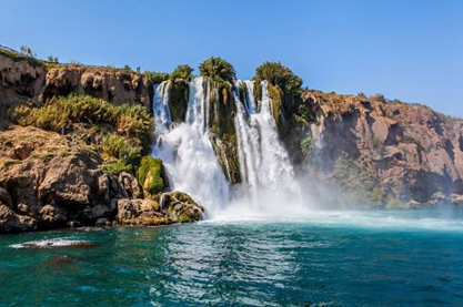
After Düdenbasi, the waters of Düdençay separate into a number of streams for irrigation purposes that reform into one flow and finally, east of Antalya, cascade 40 metres (131 ft) from a platform into the Mediterranean. A park surrounds these waterfalls. They can be seen to advantage from the sea by taking a boat trip from Antalya yacht harbour.

The Aksu River has a more marked course than the underground channels moving the water though the Duden Falls. In the forested area to the south west of Isparta and the southern fringe of that city it has a broad channel with a dry bed. In winter, the broad manmade concrete lined channel takes huge volumes of water during the winter months and snow melt water in the spring. Once away from its manmade heavily engineered course much of its flow slips below ground to make the other rivers and streams across the plain. It does though for much of the year have a surface presence that entrers the sea just 2 kilometres east of the falls that send the Dden stream into the sea.
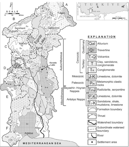
The geology of the Duden area.
Goksu Stream
This river stems from the same source as the Aksu River but not directly linked by surface water flow. Other waters enter it from the western mountains. This water mix outlining that prior to the growth in habitation of the area and as much as 1500 years ago the surface of the Antalya plain was one large delta wetland fed by waters from the Torus Mountains that surround it. These wetlands were remarkable as they were fed both by surface and groundwaters and the discharge entered the sea via waterfalls along parts of the coast as well as by small streams and rivers. Some of these later watercourses were engineered even before Roman times to allow canal bourn ships to reach up to inland settlements and cities such as Perga.
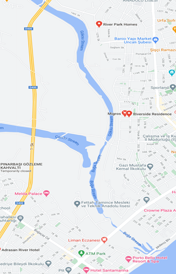
The Goksu Stream is the main component of a small network of surface waters fed predominantly by groundwaters emanating from the Taurus and the local karstic geology, though the western tributary is nearly totally a rain fed stream, especially in its upper reaches. Where the rivers join and where other surface waters add to the flow close to its Mediterranean outfall the wetland, paleochannel nature of the stream becomes plainly evident.
Western Antalya Streams.
Several small streams outflow into the sea between the old town and the Goksu Stream. It is uncertain in most instances which have been confine naturally below ground and those that have been culverted. This has yet to be fully understood.
Koprucay or Kopru Steam or Kastaraya River
This Steam has been canalised in parts from Greek/Roman times allowing river traffic up to the inland port that served Perga. The present sea access to the mouth of the river is now difficult due to silt and a change in the sea level since those times.
The main flow for the river comes from the karst limestone of the Antalya plain.
Manavgat River.
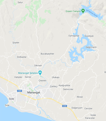
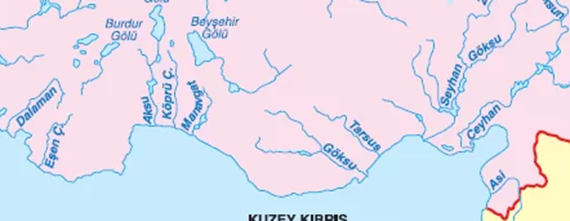
The river rises out from the same watershed as feeds all the other streams and rivers of the Antalya Plain. The water emanating from the Taurus Mountains and the area about Isparta in particular. The river passes through a series of manmade lakes producing the main supply of hydro-electricity for the region.

Pollution.
The area has many stories to tell of river and groundwater pollution and that the city’s drinking water suffers due to this proble, but there has been little published of note on the subject. The only test have been carried out by groups from local and Istanbul universities working on two sets of boreholes but down in 2002. The researches used these sites between 2003 and 2007 and 2016 and 2018 with publication of findings in 2019. The two waters studied being the Goksu and Durden streams. (See plans below.)
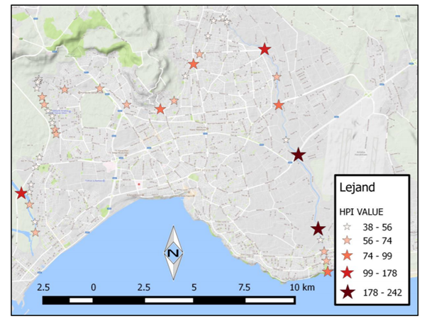

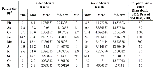
The chart above shows the only breach in water quality stands were Sr.
Bacterial analysis though not reported in these studies demonstrated a marked improvement during the research periods.
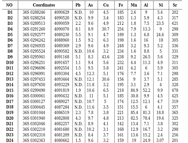
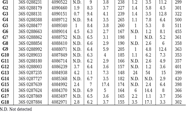
After LEVENTELI, Y.1 – YALCIN, F. – KILIC, M. 2019.
Appendix A
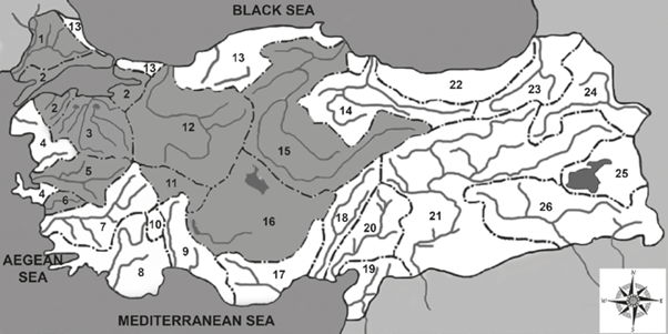
The distribution of river catchments in Turkey: 1-Meriç-Ergene River Catchment, 2-Marmara River Catchment 3Susurluk River Catchment, 4-Northern Aegean River Catchment, 5-Gediz River Catchment, 6-Küçük Menderes River Catchment, 7-Büyük Menderes River Catchment, 8-Western Mediterranean River Catchment, 9-Antalya River Catchment, 10-Burdur River Catchment, 11-Akarçay River Catchment, 12-Sakarya River Catchment, 13-Western Black Sea River Catchment, 14-Yeşilırmak River Catchment, 15-Kızılırmak River Catchment, 16-Konya Closed Catchment, 17-Eastern Mediterranean River Catchment, 18-Seyhan River Catchment, 19-Asi River Catchment, 20-Ceyhan River Catchment, 21-Fırat River Catchment, 22-East Black Sea River Catchment, 23-Çoruh River Catchment, 24-Aras River Catchment, 25-Van Closed Catchment, 26-Dicle River Catchment (according to Akın and Akın, 2007).