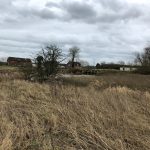
The area of land to the north of the village of Hesketh Bank and bordered by the rivers Ribble and Douglas are the largest area of Grade A agricultural land to not have an internal drainage authority or flood committee in England. This anomaly has brought about major expenditure by the Environment Agency in ‘rewilding’ the land beyond the New Bank Drain in conjunction with the RSPB and Lancashire Wildlife Trust. Much of this land which was reclaimed salt marsh has returned to the same. The to the south of the New Bank Drain being allowed to remain as high production agricultural land because it protects the village of Hesketh Bank and the villages beyond from both sea and fluvial flooding. The Environment Agency considers habitations and societal infrastructure as a priority whilst any agricultural land of what ever quality as not important, though as in this case any prolonged inundation from the Ribble or Douglas rivers would severely impact on agricultural production and impact severely on the at present high fiscal value of the land. Since 1996 when the Environment Agency was formed there need to protect agricultural land was not inherited from the National Rivers Authority (1989 – 1996) or its predecessor the Northwest Water Authority (1975 – 1989). The area did have a Drainage Committee that had its role subsumed by the Lancashire Rivers Authority during the 1960s and which were passed onto the NWWA in 1975.

The change in water management brought about by the creation of the Environment Agency was simple and to many farmers it is now terrifying. Prior to 1996 the management of water and its drainage was conducted by statutory responsibility. Today it is no longer such but at the discretion of the Environment Agency.
In the last 28 years since 1996 several floods across the farmlands bordering the marsh and margined by the rivers Ribble and Douglas have occurred. The main breaches in the banks have occurred on the north and east of the lands with major effects to both crop production and soil health. With the rewilding project along the southern bank of the Ribble Estuary the Environment Agency re-engineered the profile and capacity of volume flow of the New Bank Drain which is now the main protection of the farms and village of Hesketh Bank village. The design was stated to be capable of withstanding a once in 75 years event and has already, since 2021 been breached.

The planning of foodbanks for once in 75 or 100 years has been demonstrated over the last number of years to be based on false premiss and that these are usually breached 2+X per decade due in pard to changes in weather patterns, climate disfunction and engineering shortcomings.
One farmer who has been closely allied to the drainage of the landscape from the 1960s to the establishment of the Environment Agency in 1996 has major concerns as he and other farmers have noted increased sediment loadings in the drain system, particularly towards the outfall into the River Douglas of the New Bank Drain.. These have included iron discolouration. The Environment Agency have not been aware and although been informed of the issue have not visited the area. They have further not replied with any detail of the problem when asked. The increase in sediment and the ochre discolouration are a concern as this might be linked to the rebuilt New Bank eroding from its simple foundation as has been seen in other locations over recent years. Earthen banks and dams have an uncanny ability to liquify from the inside but appear to maintain their natural external appearance until a weight of water builds up and the shell of the bank breaks down allowing the water to pass on over the once protected landscape.

The ochre colouration that has been noted has no easy source but may be linked to the Sherwood sandstone that underlies the peat and soils. The interaction of the bank erosion hay be hydraulically lifting iron from within the rock formation.
References:
Hesketh Bank & Tarleton Internal Drainage Committee. Minute Book No. 2. 1972/73
file:///C:/Users/harve/Downloads/06b81937a0558aed9ff4d61adb651d73-compressed%20(3).pdf
https://www.lancs.live/news/lancashire-news/devastating-flooding-could-cost-hesketh-18883211
https://www.deanechurch.co.uk/library/BooksDigital/Baines/LancashireVolume3.pdf
https://www.rspb.org.uk/days-out/reserves/hesketh-out-marsh
https://www.rewildingbritain.org.uk/rewilding-projects/hesketh-out-marsh
https://www.researchgate.net/publication/245409224_Managed_Realignment_at_Hesketh_Out_Marsh_West
file:///C:/Users/harve/Downloads/ALC%20survey%20Report%20ALCW08196%20(1).pdf