The River Thames is ranked amongst the most famous waterways in the world. It has been the centre of Britain’s worldwide shipping and maritime influence. It is the river of London, a capital’s river, a Royal River and the second longest river of the United Kingdom and third in the British Isles.
The river is exclusively a southern English river that flows through picturesque countryside, villages and towns: rising in Gloucestershire and flowing eastward, eventually, as it reaches the North Sea separating Essex and Kent by its broad estuary. The river has always been a working river, the main form of transport for cargoes and passengers for thousands of years.
Like all rivers it has its peculiarities; including that it takes its Latinate name, Isis, whilst passing through the academic cornucopia of Oxford and once past the sculls course returns to its familiar name again. It is a river that has many locks, bridges and ferries, no fords and was the first river in the world to have tunnels driven beneath it for pedestrians, railways and road traffic.
The River Thames is the most written about river in history, today on ‘Amazon’ over 10,000 book titles were available with 53 new titles to be published in the next month. The academic literature review can site over 250,000 ‘Thames’ related papers and texts published in the last forty years and an innumerable number previously. A river of words, similarly a tsunami of paint has depicted this river, from its headwaters to the sea; famous painters, jobbing artists and amateurs have all captured or recorded their own responses to this waterway. Music has been composed for events on or about it from Handel to the Kinks. It has been the home of English, British and Dominion governance from the Roman period and with a few brief interludes of relocation has remained so since before the Norman Conquest.

Waterloo Sunset
This fact alone ensured that all who wanted to succeed at court or in government were sure to live in or close by the capital city, the Thames being the main highway for many hundreds of years its banks developed a startling number of great houses and famous architects and families demonstrated their capability and positions in society by their works. Even today the modern equivalents of Cardinal Wolsey still want their fine buildings to be seen from the Thames; the land that is available for such structures welcomes the like of Canary Wharf Tower and the Shard. These palaces of corporate mammon have replaced those of the private individuals and monarchs: Hampton Court or Greenwich Palace. They all speak or resonate with the same eloquence.
Power to drive industry in the capital and Home Counties has always been generated along the Thames and its tributary valleys; for centuries by water mills and later in the Nineteenth and Twentieth Century by coal burning; also oil and gas fuelled power stations. The best known of these was Battersea on the South Shore in the capital. The largest power station complex on the river today is that at Didcot in Oxfordshire. Didcot A being a coal, gas and mixed biomass plant whilst Didcot B is a combined cycle gas turbine generating station. The river provides these power stations with the cooling water for their turbines.
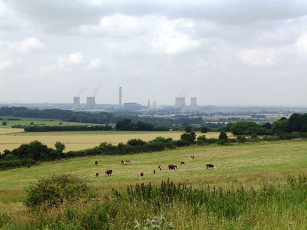
Didcot Power Stations in the Thames Valley in Oxfordshire; Voted the Third Worst View in Britain by Country Life Readers in 2003
The woodlands and forest that once bordered the river on either bank disappeared as the towns and cities expanded along its length, not just London and Oxford, but Reading Wantage, Cricklade and the others too numerous to mention. The need for fuel and building materials took most of the timber during the Middle Ages, from then the capital and the Thames Valley towns became reliant on coal, to supply both heat and power. This was not available locally, the closest available supplies being in Warwickshire and Gloucestershire but the roads of the period were poor and incapable of handling such volumes as were required by bullock cart, coal arrived instead from Newcastle and Seaham by sea in colliers; small merchant ships, giving it the name of sea coal. Once it arrived at the wharfs in London it was transhipped into lighters and barges to be transported to the coal merchants located along the whole length of the river and its tributaries.

The Collier SS Wandle on the Thames 1930
The 45 locks along the river, from the seaward end starting at Teddington in West London; the last in Gloucestershire being St John’s have and continue to allow passage for river traffic for much of the rivers length. Up stream of Teddington today the vast majority of that traffic is pleasure craft, canoes, narrow boats, gin palaces, and all manner of craft between. Three sorts of craft are drawn to the fore when considering the river, the camping skiff of ‘Three Men in a Boat’ by J K Jerome and more recently ‘Boogie up the River’ by Mark Wallington, the eights boats of the Oxford and Cambridge annual University Boat Race and the large ochre coloured estuary sailing barges or wherries that brought grain down the coast from the Essex estuaries ports of Harwich, Colchester and Maldon; wheat to be milled for the capitals bread or barley turned into its beer. All three types of craft will ply their routes as long as people love being afloat, though the wherries seldom ever move economic loads today and now race and are leisure craft.
Below Teddington Lock the river is tidal; the waterway is commercial in that it is used to transport goods and people on scheduled river buses. The old East London docklands is now the vast extension of the City of London’s business district with developments such as Canary Wharf taking the place of the banana and tomato trade. The greatest tonnage of cargo carried on the river being the huge waste arisings collected in the city of eight million people, which is removed to river skips and taken to an waste to power plant at Mucking, on the north bank of estuary by Cory Environmental services each day. Before waste was utilised as fuel the waste was for more than fifty years buried in old gravel workings on the marshes close by at Pitsea.

A Cory Waste Skip Bound for Mucking
From the refuse of the capital to the pollution of the river: a story that has been at the heart of the river for centuries. The Thames valley is a large catchment area that drains both the surface area of nearly 5000 square miles and a population of over 12 million people. The population density which has over the last three hundred years been increasing in numbers more rapidly than the infrastructure that supports it can handle.
By the 1840s the river was both the source of much of the drinking water and the main drain, not just of London but the forty odd towns and cities along its course let alone the villages and hamlets, isolated buildings and the excrement of the animals along its bank so creating a sewer of enormous proportion. In 1846 the river became so fetid that at the time and ever since it was known as the ‘Great Stink’, Parliament was suspended as the members could not debate. The need was evident that someone needed to do something: that person was the civil servant, engineer and town planner who was employed by the local authority; Joseph Bazalgette. No slouch he had plans drawn up in record time, but it took another ‘stink’ to ensure Parliamentarians voted the funding to carry out the scheme.
His scheme was so farsighted that the sewers have carried the burden of the city’s drainage for over 150 years and is only now having to be augmented with a storm water collection conduit known as the Tide Way Tunnel, which is in its final planning stages today (2013).

One of the Thames Storm Water Drains That Will Cease Polluting the River Once the Tide Way Tunnel is In Place.
Further pollution became apparent in the middle of the Twentieth Century; this was the rise in temperature, that; with urban run off and the peripheral pollutions that the river can be prone to became a biologically dead waterway. In the 1950s and 60s the water could not support life below Teddington Lock. With the closure of the London coal and oil fuelled power stations the river began to recreate itself; the tidal reaches now host over 130 species of fish and a rapidly developing avian population.
Fluctuations in river water quality are only to be expected as the water environment is the receptor of all our liquid wastes, human and chemical. The chemistry of sewage alters in its constituent parts; particularly through pharmaceutical developments meaning that the treatment of human waste consistently lags behind. Many pollutants that may be responsible for noticeable alteration in fish stocks, particularly transgender issues are on sewage treatment and the inability to remove materials such as estrogens from the waste waters of sewage treatment works.
The river as it flows from Thames Head is a seasonable event, when the rains make it show itself above ground: it is for the first few kilometres a winterbourne, gaining visible water flow from the Lyd Well, the river then starts to pick up stream tributaries that give it a true presence. The river though is not a wide or deep river till it nears the start of its truly navigable route at St Johns lock.
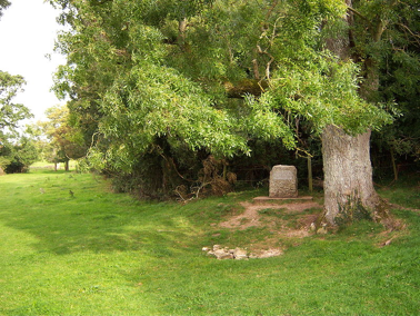
The Stripling Thames, a winterbourne at Thames Head.
The river is a quiet waterway; it has no mountains or gorges, it is an English river in that it is unassuming in its nature. Its waters when not passing through the towns and villages along its route to the sea is a rural stream, water meadows and pastoral scenes. By its nature it is a backdrop of history, its banks have witnessed English and British events unfold. The water meadows at Runneymede are a case in point, its name meaning a meadow meeting place, the Anglo Saxon Witan, a form of parliamentary assembly, met here, it is where the Magna Carta was signed by King John at the behest of his nobles in 1215: the site has seen the establishment of avenues of trees and stone monuments to freedom and libertarian belief over the last one hundred years with visits by Indian prime ministers and presidents of many countries including John F Kennedy of the United States. The water though flows by in that seemingly unending nature of all rivers.
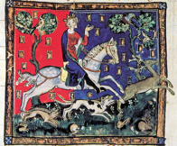 King John
That flow has been checked at times nature; particularly during the mini ice age of the Seventeenth Century when the river below and above London Bridge was frozen for months on end. The normal river business continued all the same with cargo moved along the frozen surface of the river on skids and wagons. This period saw great frost fairs take place upon the frozen surface, bonfires were lit and animals slaughtered and roast.
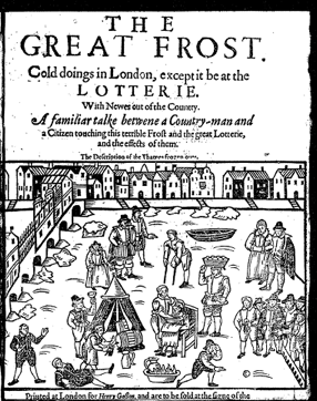
Seventeenth Century Thames Frost Fair.
The river when not solid but full of rainwater from upstream, coupled with high tides and nor easterly gale gives rise to the river breaking away from its banks. The river has always been a danger to the marshes of North Kent and Essex on the left bank. This flooding reached upstream threatening the capital itself until in the 1980 a flood barrier was constructed to lesson that threat, with global warming and increasing storm events the structure is fast becoming redundant and a new barrier is to be erected to forestall inundation of the City for another forty years.
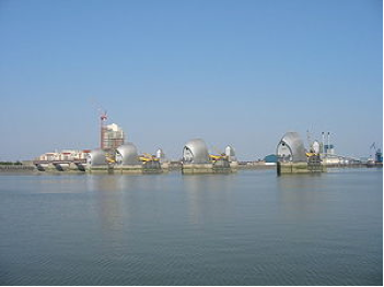
The Environment Agency’s Thames Barrier
The shore beyond the barrier is another story; Dickens travelled the marshes where malaria or ague was rife, prison hulks shacked to the mud, sunken ships, such as the Richard Montgomery which lies off the entrance roads into the River Medway. Along the coastal fringes of the great estuary forts and castles, pill boxes and sea forts show how the river was protected from the enemies of the day, Scandinavian, French, Spaniard, Dutch and German; the Dutch being the most intrusive.
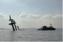
USS Richard Montgomery
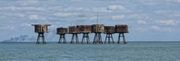
Tames Fort; Red Sands
Take one hundred people and ask them to describe the River Thames; you will receive one hundred different descriptions.