Introduction.
The abandoned mines of the area are presently filling with water since closure of the collieries at the end of the 20th Century. Since mine closure, the South Nottinghamshire and Derbyshire Coalfield has been considered a problem for the Environment Agency, the Coal Authority and British Geological Survey. The later organisation did the unusual thing and got the story wrong. Their prediction modelled and trumpeted that the minewater of the whole region might be best managed from the shaft at Calverton Colliery (At closure, the flow of water into Calverton was approximately 2 L/s made up of 0.7 L/s from Bestwood, 0.5 L/s from the shafts, and the remainder from Calverton workings C/A report 2012). There is currently a slow rise in the mine water level, and the depth to water at WYG Engineering WYG Engineering part of WYG Group creative minds safe hands www.wyg.com A031899-2 Page 249 of 319 Overview of mine water in the UK coalfields 2010/2011 Calverton is currently 466 metres. The time scale was set for pumping from the shaft left open for the purpose was 20 years from the close of Annesley Bentinck colliery and its pumps being turned off. Pumping ranges were placed in the shaft in readiness at Calverton. The water has never arrived. Which in retrospect was lucky for the environment, as the water that was planned to be taken from the shaft was to be put through a lagoon and reedbed system to remove the ochre and other metals, and the discharge to the Dumbles, a group of streams close by the colliery site at Calverton. The water would have decimated this important SSSI with the high chloride discharge that was expected from the discharge water.
The Coal Authority also considered the option of piping the water from the settlement lagoons to Stoke Bardolph Sewage Treatment Works as a last resort solution, but Severn Trent Water the owners and operators of the site were not certain if they could gain an added chloride dispensation on their discharge consent from the Environment Agency.
Many of the mines within the region historically discharged high levels of chloride in their drainage waters that came from the deep mines’ geology. Today the Coal Authority discharges one such water from it is a Winning pumping station into the Normanton Brook. The discharge has allowed for some strange occurrences with regard to aquatic fauna such as sea snails being found to live 100 miles inland from their nearest natural habitat.
The largest historic discharge of minewater was from the drainage of Annesley Bentinck Colliery, a combined pit (1986) that discharged its treated minewater, which, passing through a series of settlement ponds to the side of Annesley site close to the site of Newstead Colliery. This water was again chloride rich and was planned to be routed to the headwaters of the River Lean, but this was decided against by British Coal after an acidic discharge (pH3) earlier in the decade had damaged the ecology (killing several hundreds of trees and wiping out fish stocks and other aquatic life) of the upper lakes at Newstead Abbey (belonging to Nottingham City Council). The change of route for the minewater required a large expenditure with British Rail for way leaves and engineering costs which allowed for a 17.5-kilometre pipeline to be installed along the railway lines to and past Nottingham to the River Trent near opposite the Attenborough Nature Reserve. This was felt would allow the only possible dilution factor of the chlorides present in the minewater.
With the discovery that Calverton mineshaft was not the Environment Agency and the Coal Authority have sadly behaved in a somewhat secretive manner with regard to the knowledge that the original plan was a nonrunner. The questions that needed to be addressed first was what was to be done regarding minewater management in the South Nottinghamshire Derbyshire area. There is knowledge and one we have shared with the County Councils, other local authorities since Clean Rivers Trust researched a published a report for Nottinghamshire County Council in 1992 on this subject. 29 years on and the situation is becoming somewhat more urgent.
The triple issues that need to be addressed are the threats to the Sandstone aquifer and surface waters to the north and west of the city of Nottingham, and the Erewash Valley plus ground stability in the North Notts, Derbyshire and South Yorks borders.
The Coal Authority carried out an extended pumping test at A Winning minewater pumping site to test their ability to manage minewater levels across the system of mine workings to the east. This was carried out in conjunction with monitoring a new monitoring borehole into the mine workings close to the old Linby Colliery site. The chloride levels from the pumping resulted in a threat of prohibition of pumping and this experiment was cut short.
The monitoring of the levels at Linby (started 2011) did demonstrate that the minewater within the Annesley Linby area was increasing (2018 2020), and that allows for some extrapolations as to the reasons why minewater has not reached Calverton as was previously expected though the Coal Authority did not fully believe that the date of 2020/2022 water was not going to finally reach Calverton which would still see water materialise in the shaft. The Coal Authority had though now had to accept that the water was not behaving as expected/hoped for due to new research by the University of Nottingham and British Geological Survey. (Fig. 12).
Minewater monitoring boreholes were also put down at Newstead, Babbington, Moorgreen, and Radford. In 2012 the Coal Authority recorded no increased water levels. This apparently changed dramatically in 2018/19 with monitoring boreholes demonstrating elevated levels across the mining area north of Nottingham. The same research also highlighted rising ground levels in the northern part of the Nottingham, South Yorkshire region. This rise should increase ground instability around Welbeck and East of Chesterfield. In the view of the Coal Authority 450 litres per second would need to be pumped across the South Nottinghamshire Coalfield to control the water build up in 2012. Annesley Colliery discharged around 52.5 litres per second and was the main discharge point in the region keeping the coalfield drained. A set of pumping locations pumping 5 times this amount will include Woodside and A Winning that are said to pump 100 and 150 litres per second, respectively.
The increase in minewater accumulating in the abandoned mine workings across the whole area is threatening the vitally important sandstone aquifer that overlies much of the region. With the latest threat now researched and pinpointed to be a threat to surface waters from Newstead, Annesley and along the Erewash Valley, plus the possible addition of rebound around Radford. British Geological Survey estimate that the dangers are imminent. There is a lack of openness and the Coal Authority appearing to sit on their hands.
In 1998 Midland Mining and Clean Rivers Trust suggested to the Coal Authority that when their mine shut pumping should continue or at least the mines made into the pumping hub for the region. The site being unique and with the pipeline to the River Trent in place ideally suited for the purpose. The turndown startled management at the mine as they were aware of water flow problems towards Calverton. The Coal Authority abandoned the pipeline in 2000.

Fig. 1 The geology of the region is important, the Triassic and Permian sandstones being part of one of the most important aquifers in the country. As is noted on fig. 2 the dip in the strata is from west to east. The coal seam continuing beyond the county of Nottinghamshire and beneath Lincolnshire to beneath the North Sea.

Fig. 2 An Edwardian plan of the exposed coalfield (black hatching) and the millstone grits that underly it and outcrop to the west.
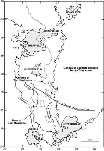
Fig. 3 A modern overview of the exposed coalfield. The cross section indicated on the map is below as Fig. 4.

Fig. 4 The cross section shows detail of some seams worked from each colliery. Calverton did not work the Blackshale coal that was extensively worked from Annesley Bentinck. Annesley Bentinck being the main pumping station from which water from the outcrop was managed. See Fig. 6.
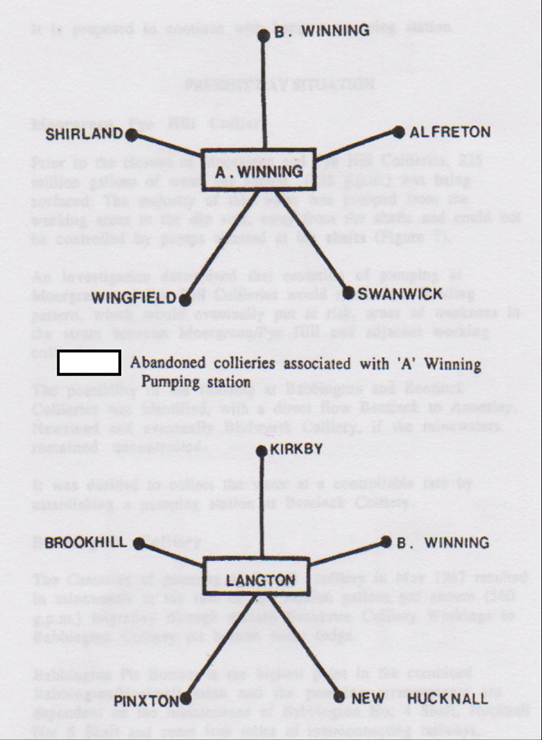
Fig. 5 This starts to demonstrate the complexity of the problems of gaining an understanding of the drainage of the South Nottinghamshire Coalfield. A Winning pumping station protects the deeper eastern coalfield from inundation from the wet coalfields to the west of the area, as did Langton. Langton pumps were tuned off to maximise the value of the pumping range at Annesley Bentinck.
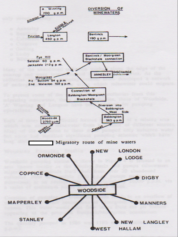
Fig. 6 Demonstrates well this complexity of water management. The mines shown being the most recently active in 1980s. Mine drainage from the west was in reality that of several hundreds of coal workings, similarly the pumping station at Woodside (pumping about 150 l/s 2012) protects the Derbyshire pits from both overtopping within the Ormand and Shipley basins which would otherwise overspill into the River Amber and Bottle Brook. The Annesley Colliery pipeline and the pumping lodge at Bentinck combined could take all the water from the West not picked up by A Winning and Woodside and so preventing water build up to the east of Linby.
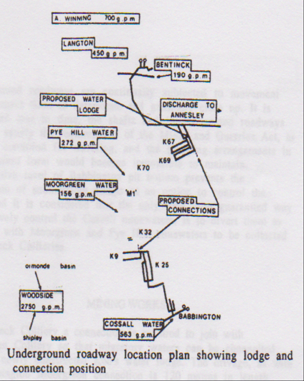
Fig. 7 This plan demonstrates the direct linkages between collieries in the Blackshale seam of coal to the west of Annesley. Volumes of water moved from certain collieries is given as GPM (gallons per minute) pumped. The roadways demonstrate the routs of water transfer on installation of the pump lodge at Bentinck and the water transfer to the River Trent via the pipeline.
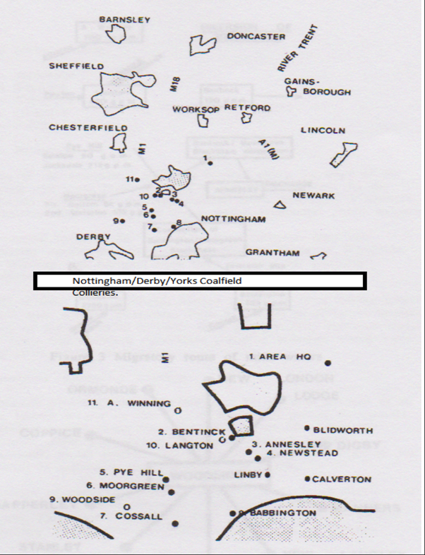
Fig. 8 The upper plan shows the whole coalfield in context to its surrounding towns. The lower shows the South Nottinghamshire and Derbyshire Coalfield with the operational pits of the 1980s in relation to one another.

Fig. 9 This is the plan that has proved to be inaccurate to such a degree that it allowed for a long period of inactivity by the Coal Authority who relied on its accuracy to explain what it was preparing to do to protect both the major aquifer and the surface waters of the region. The greatest tragedy being the filling of the shafts at Annesley along with the Coal Authority voluntarily giving up the pipeline from Annesley to the River Trent.

Fig. 10 Nottinghamshire County Council, Coal Authority
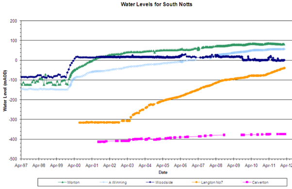
Fig. 11 Shows the level of minewater within the mine system across the Derbyshire Nottingham border mining region plus the low water level at Calverton.
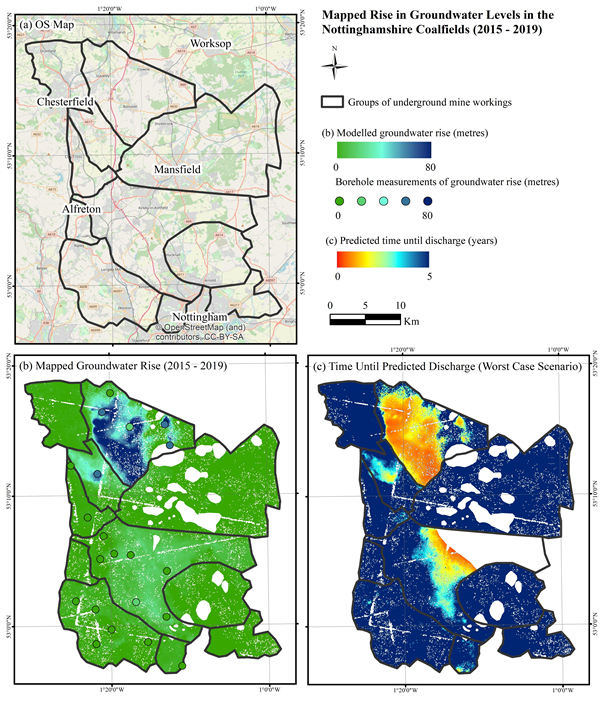
Fig. 12 A Coal Authority set of plans for South Nottinghamshire and Derbyshire demonstrated by BGS for the Coal Authority and published by the University of Nottingham, November 2020. These demonstrate a dynamic set of predictions of near future events and a long way from Calverton.

Fig. 13 Plan showing the location of the minewater monitoring borehole site at Linby.
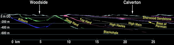
Fig. 14 1996 BGS, Environment Agency section of the coal seams displaying the synclinal nature and the severance of the Woodside ponding and low transmissivity to the rest of the coalfield with regard to the deep hard coals. The Kilburn seam is less isolated with possible spill over towards Annesley and Newstead. The linkages from the extremities of the Newstead workings being checked by engineered stoppings to deter water infiltration towards Calverton.
References and Sources.
file:///C:/Users/harve/Downloads/CA-2356-Linby%20Borehole-Gas%20Risk%20Assessment.pdf
https://www.imwa.info/bibliographie/07_1_009-024.pdf
https://www.imwa.info/docs/imwa_2000/IMWA2000_7.pdf
https://www.cleanriverstrust.co.uk/
http://www.shipleylakeside.co.uk/history.html
https://www.jstor.org/stable/634240?seq=1
http://eprints.gla.ac.uk/120112/7/120112.pdf