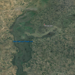
Annesley is a mining village to the north east of Nottingham. It is notable for being situated on the outcrop of the Sherwood/Bunter sandstones that make up the main geological cover to the east and overlaying in part the Carboniferous limestones which outcrop a mile or so to the west. Beyond that the coal seams start to outcrop into the River Erewash valley.
The Annesley Colliery pit top was a fine example of a Victorian coalmine (sunk in 1876) that continued to cut and raise coal up to the last year of the Twentieth Century. During its latter years of production being the location for the engineering and man access, coal being removed by the drift at the next door operation at Bentinck Colliery. Annesley was also the location for the treatment of the waters that had to be pumped from the mine to allow coal to be won below ground. It was known as a low water producing mine with its operations being relatively dry. The water the mine needed to remove from its workings to protect itself came from elsewhere in the labyrinthine interconnected workings stretching north and west towards the outcrops of the coal in Derbyshire. The pumping of these 1.2 million gallons a day was a constant issue both below ground and on the surface.
Similarly the pit top at Annesley was extensive; the surface if the site set up on the side of a hill overlooking the headwaters of the River Lean. Around the northern and eastern sides of the site large pit tips dominated the immediate view. From the top of the tips the areas natural drainage pattern was plainly visible, the Dumbles; the Lean headwater catchment and the Lean Valley beyond Newstead and its lakes. Beyond that the Trent Valley and Ratcliffe on Soar coal burning power station in the distance.
The drainage from the colliery and its top right up to the 1960s had been Victorian; rudimentary and basic. The mine water from the colliery, as already noted, was a small volume: the increase in the pumping came about when the surrounding pits closed down and ceased managing their own waters and the pumps that dewatered them were shut off.
The water from Annesley mine; both the pumped and surface were allowed to drain down the hill to the Dumbles, flowing through Newstead Abbey lakes and down the River Lean. There were water quality issues, coal dust and detritus, occasional variation in acidity of the water, iron staining, but nothing unusual for the receiving water that was the natural route for waste waters from other collieries and other sources, manufactories and sewage works.
The 1960s saw the beginnings of major shrinkage in the coal industry, mines up dip of Annesley started closing: some water stoppings were placed strategically underground between the closed and active areas to protect the working deeper mines. These water stoppings gave protection, but some of the stoppings were better engineered than others; the water pressure that built up behind them could be immense.
In 1999, not long before Annesley closed, there were meetings between the surveyors of the mine and the owners to discuss the best methods of relieving pressure at one stopping that was some miles away from the working face where coal was being cut. In the 1970s these hydraulic barriers started to fail with the result that to protect the working faces of coal and continue production the working mine had to increase pumping rates. This led to at one period the pit having to remove over 4 million gallons a day of inflow water at the time of inrushes as the up dip stoppings failed. This was both to protect the economic coal seams and even more vital to protect the miners from inundation; one of the great fears of those labouring beneath the surface of the earth.
The initial action when pumped water volumes from below ground started to increase so dramatically was to continue to discharge the water to the River Lean headwaters, but via a huge holding lagoon that was constructed on the top of an old spoil heap overlooking the Lean Valley, this lagoon was found to be inadequate to hold the volumes of water that were being brought to the surface and control the discharge to the river so a further two holding lagoons were constructed at decreasing levels on spoil heaps adjacent to the first lagoon. This whole lagooning operation covered above 600 acres of land.

Annesley Colliery from the air in 1996 taken as part of the 10 year Environme3nt Report.
The three large ponds on the spoil heaps are clearly visible, the smaller lagoons and pumping station that sent the minewater to the River Trent are to the south east of the first ‘ochreous’ lagoon. The Dumbles surface water lagoons are to the right of the second large lagoon and bordered by the ploughed orange/brown field; the stream passes out of the picture in the right hand corner of the photograph.
These lagoons did what was required of them at the time, hold water, they also allowed some of the iron that was in the water to precipitate out of the minewater as ochre but the water volume into the headwater of the Dumbles was significantly increased and the top lakes of Newstead Park were flooded where in the past water levels had been decreasing, due to over abstraction of ground water from the Sherwood sandstones of the area for drinking water.
Newstead Abbey.
The water quality of the minewater discharge was decreasing in other ways as well as its having elevated iron content the water was becoming acidic (pH 6 – 3.7) and showing an increase in chloride content. The wooded banks of the lakes running into Newstead park were being inundated with this unpleasant polluted stream, the consequences were that many of the trees died, fish and other aquatic life was wiped out; the lakes were biologically minewater and to the publics’ mind moribund. The Trent River Board at the time stepped in at the request of Nottingham City Council, the owners of Newstead Abbey and Park. The damage to the landscape proved to be considerable to the lakeside woodland: the damage is still visible today nearly 40 years on.
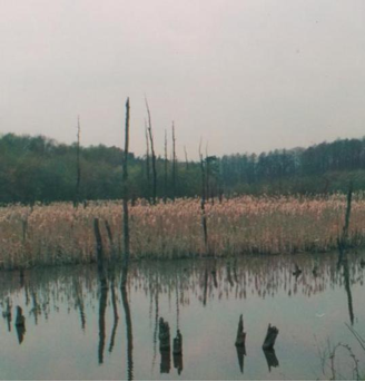
Lake and natural reed bed with dead trees photographed in 2011 more than 35 years since the chloride rich and acid waters past though the Newstead Lakes.
Urgent discussions were carried out to see what could be done to alleviate the plight of Newstead lakes and the River Lean, the planning issues were not to be a problem; an advantage of a public company (the Nationalised National Coal Board as it was at the time) that was not wishing to get into further conflicts with local authorities with regard to operational issues as there were planning issues aplenty with regard to opencast coal mining applications.

The minewater entering the top lagoon at 27o Centigrade.
The solution to this problem was to remove it from the Lean catchment altogether. The volume of pumped minewater steadied down to less than 2 million gallons per day and a chloride level that would salt a healthy lobster. Plans were put together that would relocate the discharge to the River Trent some 17.5 kilometres away to the south. The Trent River Board felt that the main midland river, the third largest in the UK could cope with the chloride levels by dilution with the main river flow. The route of the pipeline was agreed and was to follow to a great extent the route of the mineral railway line (today the Robin Hood Line), though bypassing Nottingham City centre to the West. This was a remarkable route that could only have been economically agreeable as the railway company, British Railways would have charged a kings ransom for such a way-leave. That the two organisations, National Coal Board and British Railways were both nationalised companies which made it politically possible, a private company could never have been able to afford such a route and the mining would have had to cease 25 years sooner than it did. The mining industry in the 1970s was a major force in the land as its power was predominantly supplied by ‘home’ produced coal and the Nation Union of Miners had as much or more political force than did the Chairman of the Coal Board.
The scheme was put in place by the end of 1978 and functioned well till pumping ceased at the end of the millennium. There were problems regarding pH, pumping line blockages; pressure was increased in the range and a pig, a solid rubber projectile released down the pipe. These objects were found by anglers along the Trent bank, thinking they may be warheads called the bomb disposal squad out.
The acidity problems were resolved with lime dosing of the ponds and the placing of ‘dekka’ blocks in the spillways between the lagoons. Further ‘stilling’ or settlement ponds were added to the three major lagoons in the 1980s to help remove further iron from the discharge just before the entrance to the pumping station which was also replaced at that time. The lower of the three original top lagoons was taken out of commission at this time as it was found to be unstable and starting to slump. It was though retained as an emergency resource in case extra capacity was required into the future.
The cessation of minewater leaving the colliery to the Lean catchment led to increased scrutiny of the surface water discharge which could be quite variable in its content; oil and greases were commonly found to be washing into Newstead lakes. This led to the putting in place of a series of lagoons that were designed to allow treatment of the colliery top surface water and any other runoff that might occur on the eastern edges of the mine’s estate. This allowed for the Dumbles to flow through the lagoons.
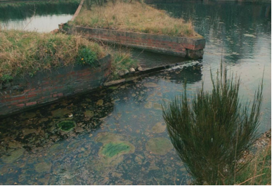
Part of the lagoon system taking the surface4 water from the pit top and the flow of the Dumbles stream. The scum and algal growth show what turned out to be in part bacteria, particularly Thiobacillus ferroxidans. This is one of a great many bacteria that are known as sulphide reducing bacteria.
The most particular concern regarding pollution of the stream was hydrocarbons; oils and grease which were widely deposited around the workshops over the last hundred years. The answer was to place hydrocarbon retaining boom filters across each spillway where the water passed from one water body to the next. These operated successfully until the mine closure.
The Dumbles lagoons though very neglected by the end of their operational life had developed as quite important wetland and wet meadow habitat with a remarkable flora and fauna. 7 orchids were identified by Nottingham University working with the Trust. Several damsel and dragonflies were found. Several reptile species, including 3 different newts were identified.
Today the Annesley site is being developed as a housing estate by Persimmon Homes plc. The colliery top is from now to be known as Jasmine Gardens. Strangely when the drainage plans for the estate were put towards the Environment Agency for approval the surface drains ticked all the sustainability boxes by consigning the water to soakaways located about the development. The knowledge of the original systems had been lost: the soakaways though will still supply the Dumbles with their birthright of the pit top drainage.

Annesley Colliery after the site had been cleared for development. The top lagoon has been filled though the shadow of its shape is still visible. This was due to the constant feed of water that was feeding a perched water table that would have liquefied the whole bank of the waste tip. The newer ponds have also been filled and the pumping house has gone. The pipe still exists between the site and the River Trent. The second lagoon still holds some surface water, the signs of water channelling down left hand corner is of interest as this borders a steep bank that could become unstable. The surface water lagoons can just be seen on the right of the picture.
Harvey Wood.
August 2012.