Hydrogeology, Resources and Energy Potential.
This report has been researched and written by Clean Rivers Trust, a registered charity (No: 1037414).
72 Appletongate
Newark
Nottinghamshire
NG24 1LR
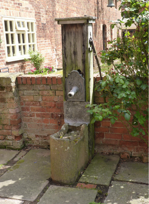
Note. The picture on cover; Water pump at Top Farm, Screveton. © Alan Murray-Rust, 2014. Creative Commons.
The Author being Dr Harvey Wood Dip AD, FRSA, FRGS, FGS, FLS; Director of the Trust.
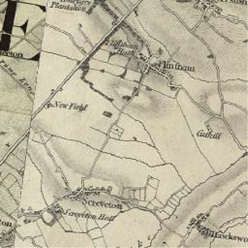
Fig 1. 1870 Ordnance Survey of area of interest.
Introduction.
The purpose of this overview is to consider the various aspects of the village of Screveton with regard to water and the hydrogeological resources that might be developed to supply sustainable energy resources. These resources are to be at least low carbon; preferably carbon negative or neutral. In so doing other resources such as coal and oil have been looked at to set them in their place within the pantheon of resources that have been considered.
The paper attempts to understand the basic historical and geographical setting of the area to understand and explain the setting of current need and possible sources that might otherwise be overlooked.
Some consideration during research has been applied of the activities, economic and cultural that have taken place in the area; for so small a village and its community the continuum of activities has been striking. This study has noted several facts as to historical background and issues such as population. These have included the agricultural depressions of the 1880s and 1912/13 (Fig 3 & 4) also the effect of the First World War (Fig 3), more mundane issues such as the arrival of mains water supply is also of vital influence to the villages development.
Historically and geographically the village of Screveton is a good demonstration of a sustainable community over at least a millennia with little expansion of the central village nucleus or envelope. The 1000 years of near little change year on year till the ‘modern era’ that brought power supply, water, telecommunication and availability of travel: even now there has been no rapid changes in the built village environment, the most startling change over the last 60 years being the makeup of the population. The farms had been the major employer of the population in the past. Others found their living as inn keeper, carter, and blacksmith; there as also service at the hall and parsonage.
Today farms employ few and the majority of inhabitants in communities such as Screveton work away from the village or are retired. Such callings as publican, grocer, carter or blacksmith have ceased to exist as has the servant. The framework of a sustainable village has altered to be reliant on outside income generation and looks beyond its boundaries to receive the staff of life; shopping, income, services, culture, entertainment. Such a society is much more fragile than it was at any time of the last 1000 years.
The desire for the redevelopment of a sustainable village; in that it begins to look inwards to its own resources and intellectual strengths, though aided by external grants and the importation of expertise so that this renewal is advantaged by the best available advice has only just begun. The availability of similar advice originated in the early 1700 and extended through to the 1980s with the privatisation of ADAS.
1 Screveton.
1.1 The village of Screveton lies to the south of the Foss Way, set between the larger villages of Car Colston and Flintham; south west of the market town of Newark on Trent. It is a small village that benefits from the facilities of its larger neighbours.
1.1.2 It holds an important place in the study of the history and archaeology of Nottinghamshire in that it was the birth place of Dr Robert Thoroton who in 1677 published the first history of the county. There is a learned society that carries his name today that continues historical enquiry into the county. The Thoroton family being Lords of the Manor at that time.
1.1.3 The village was noted in the Doomsday Book of 1086 as of taxable value of 1.5 geld, of value to the Lord of the Manor; Hugh nephew of Herbert son of Ivo (in 1066 it had been Toti of Screveton), £1.6 as rent. The payee being Bishop Odo of Bayeux. The village comprised 4 villagers, 1 smallholder, and 5 freemen. The land use was broken down as 3 ploughlands, 3.8 men’s plough teams and 12 acres of meadow land. (Fig 2)
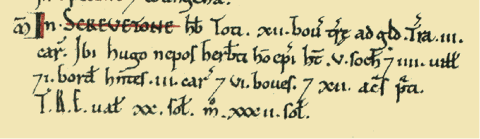
Fig 2.
1.1.4 The population of Screveton has grown markedly in the last part of the 20th Century: in 1951 103 persons lived in the village, in 1961 121, the number rose to 137 in 2002 and has levelled off as the local authority estimate for 2012 demonstrates being 135. It is noticeable that population has grown little compared with the number of dwellings mirroring a national phenomenon that household resident numbers have declined. (See Fig 3 & 4.)
1.1.5 Unusually the mixed nature of the Parish’s land use has changed little over the centuries since the Norman Conquest with a mixed agricultural regime still practiced. Both arable cropping and livestock are farmed productively.
1.1.6 The village before the provision of mains water was reliant on wells and rainwater cisterns for its potable and domestic supplies, which has a remarkable influence on the village population. In fig.2 it can be seen that after the decline of population after the 1912/13 agricultural depression and 1914-18 war the population returned to its more normal pattern around 1950; at about this time mains water came to the village allowing continued growth to its current equilibrium brought about more by planning control than water issues. The population would have levelled off earlier if it had to rely on a locally sustainable water supply.
1.1.7 The residential property drainage of the village is by packet treatment plant, septic tank or cess pit
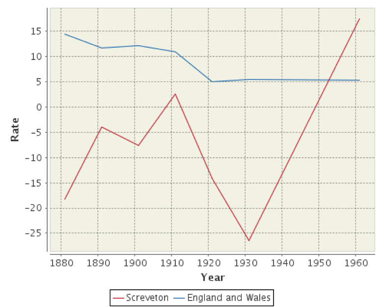
Fig 3.
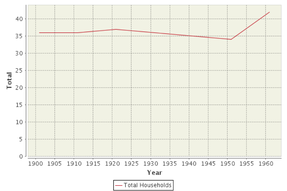
Fig 4.
1.1.8 The village water use per capita per day prior to mains water being connected is unquantifiable. In 1955 the village was connected and supplied by the Newark Rural District Council. Then the volume per head use was an average of 25 to 30 litres daily whereas today (2014) this is 150 litres and growing at 1% per annum. These volumes include drinking, washing and bathing. Such volumes of modern water use would have been unlikely to have been achievable using local water wells.
1.1.9 There are no Environment Agency Water Abstraction Licenses at present in force within the Screveton Parish Boundaries. (See map; Appendix 2.)
1.2 Geographical Setting.
1.2.1 The village is set off the Foss Way (Roman Road between Widmerpool and Newark) has a population of around 178.
1.2.2 The area is predominantly rural with agriculture as its major industry. This has in part given rise to a tourist/community facility in the form of the Eco – Centre that encourages engagement with the natural world and involvement in traditional rural activities.
1.2.3 The village is surrounded by small water courses or drains, on three sides, as well as there being several springs in the area; the thoroughfare between Car Colston and Screveton is redolent of the fact in that it is called Spring Lane.
1.2.4 The watercourses being to the west Shacker Dale, the eastern watercourse is unnamed but both enter the Car Dyke that flows to the south of the village. The Car Dyke flowing north east and entering the River Devon opposite the village of Hawton.
1.2.5 The unnamed water course only rises to the north of the village by about a mile and is added to in volume by water from springs in the village.
1.2.5 The Eco – Centre publicises a small water feature that is fed by a spring line within the farm boundary.
1.2.6 Rainfall/precipitation is recorded as an average of 24 inches per annum (60.96 cm, 609.6mm).
1.2.7 The whole of the parish is in the catchment of the Car Dyke, which, along with the River Smite. Bisect the Trent River plain edged to southeast by the rising ground of the Vale of Belvoir and the River Devon.
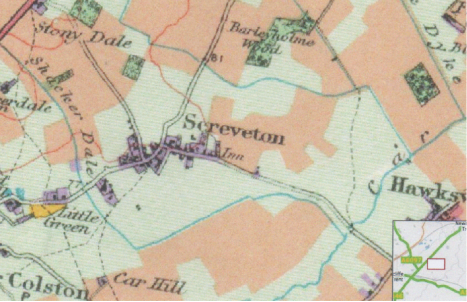
Fig 5. The Sacker Dale course around the western and southern edges of the village are well illustrated on this old land use map of the 1960s. The course and confluence of the unnamed stream is also well shown and both waters enter the Car Dyke.
1.3 Geological Setting.
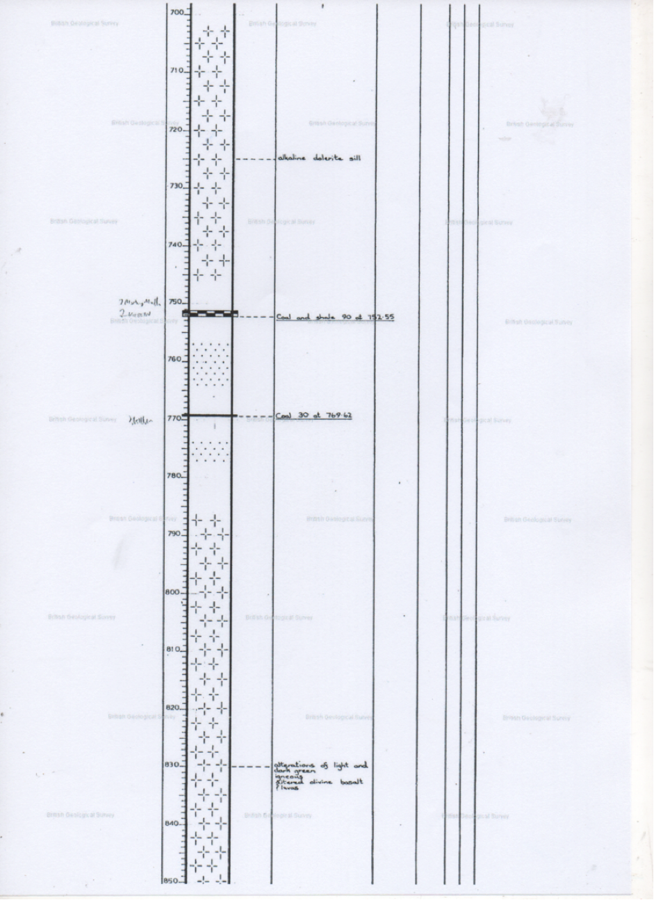
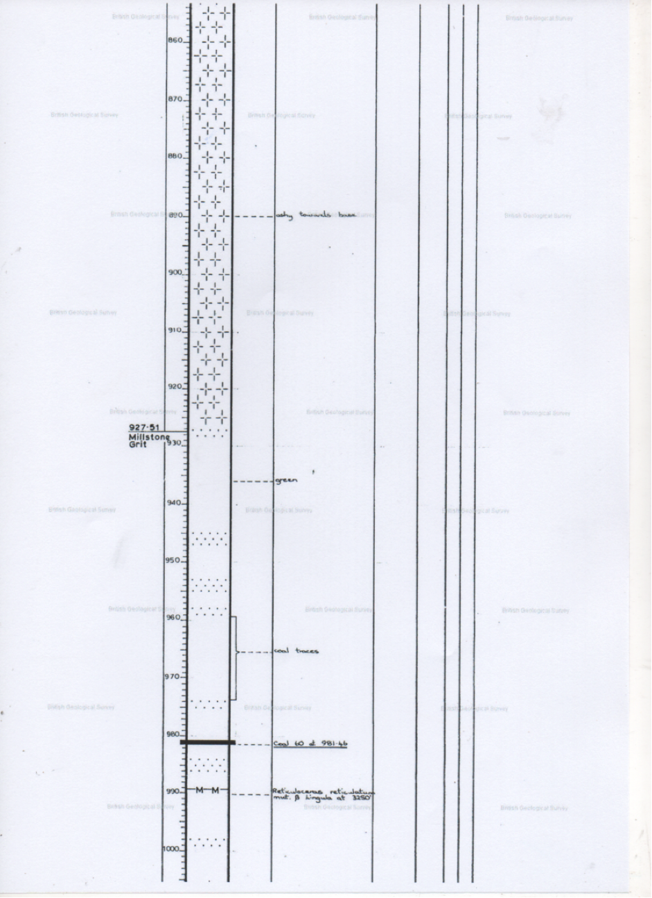
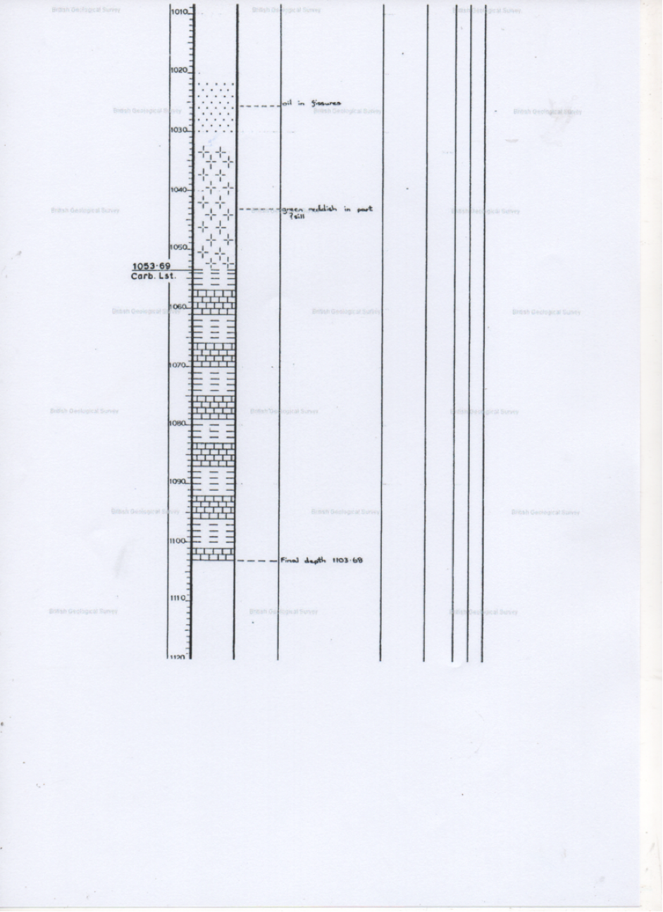
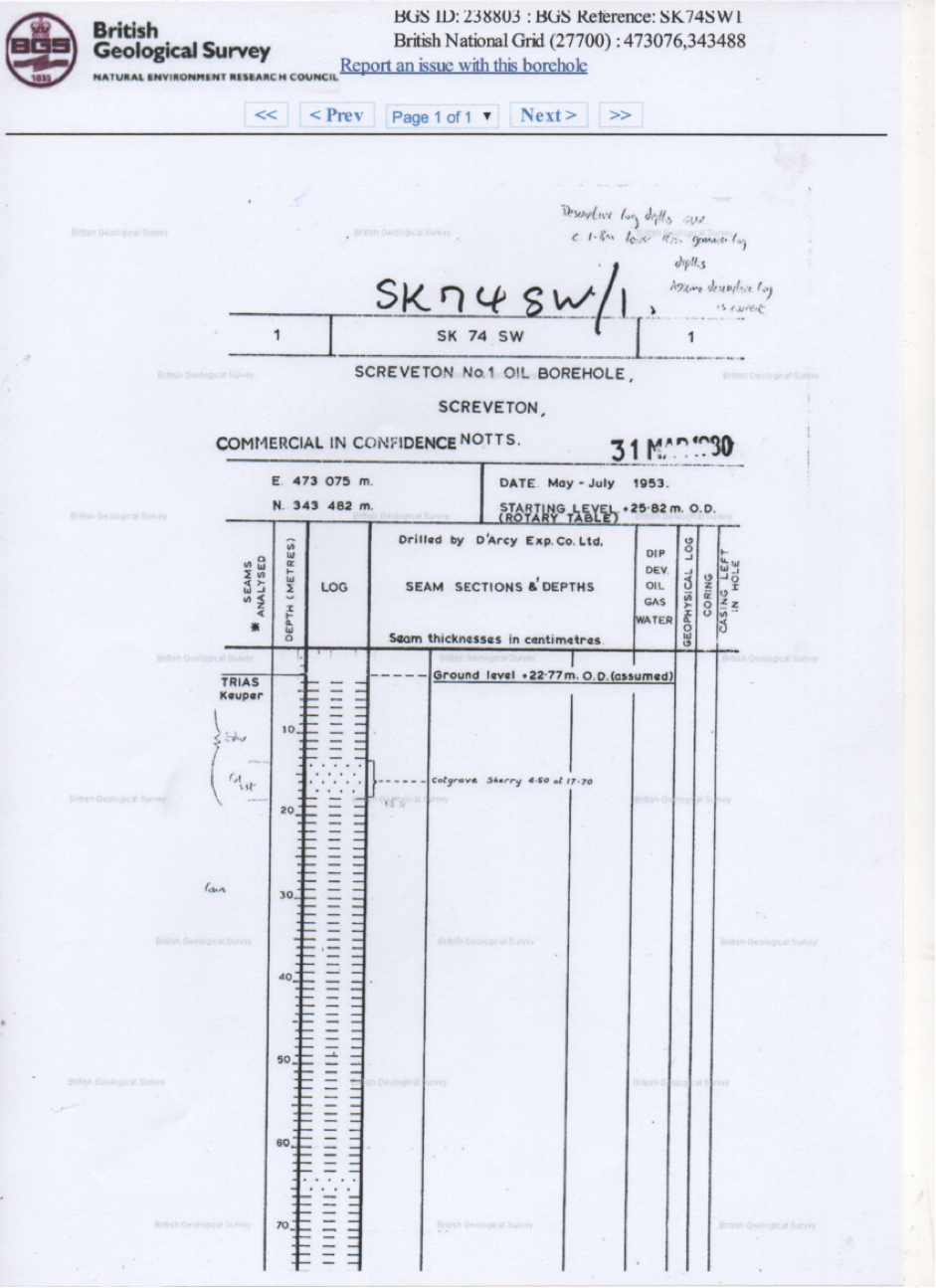
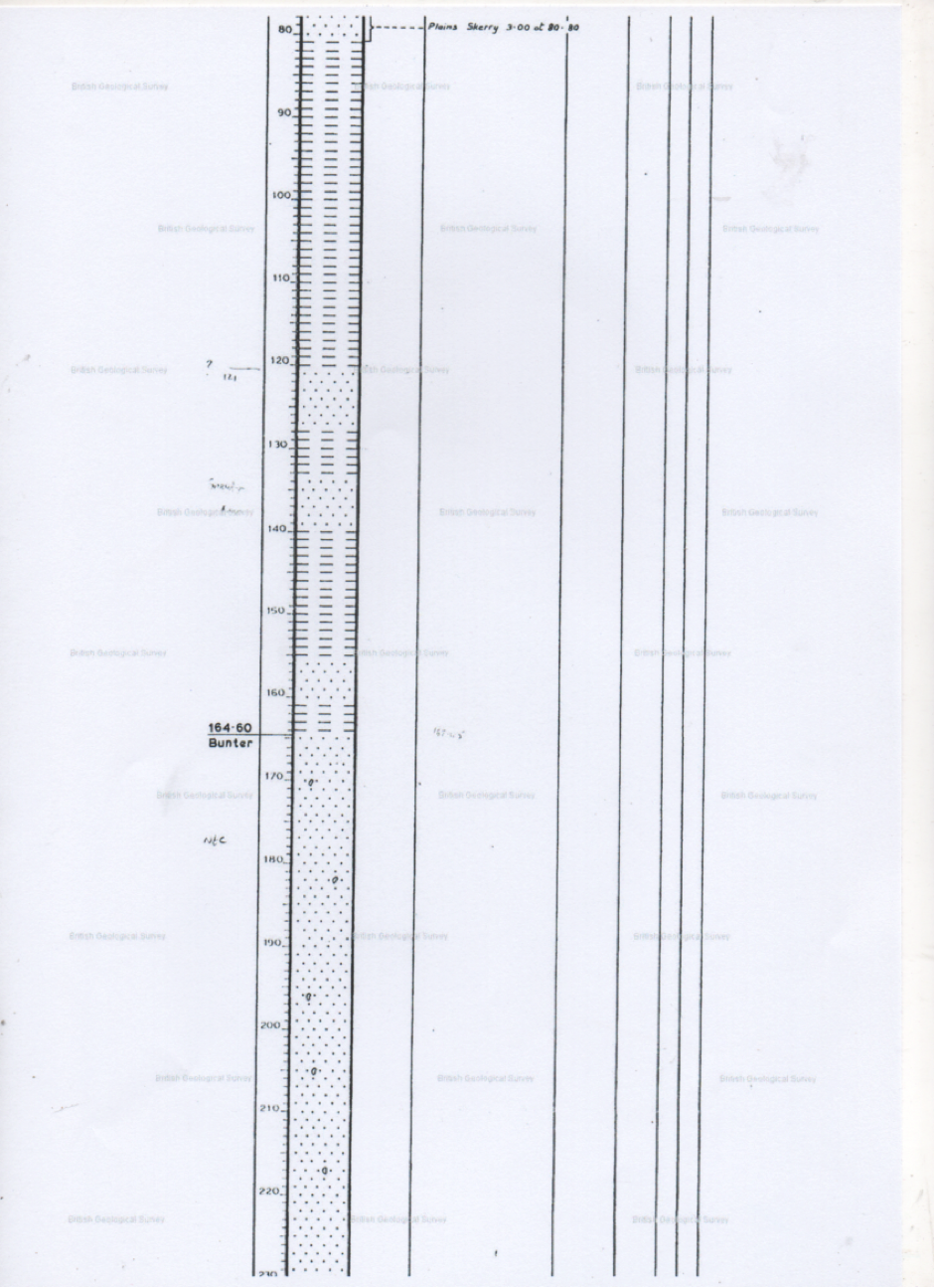
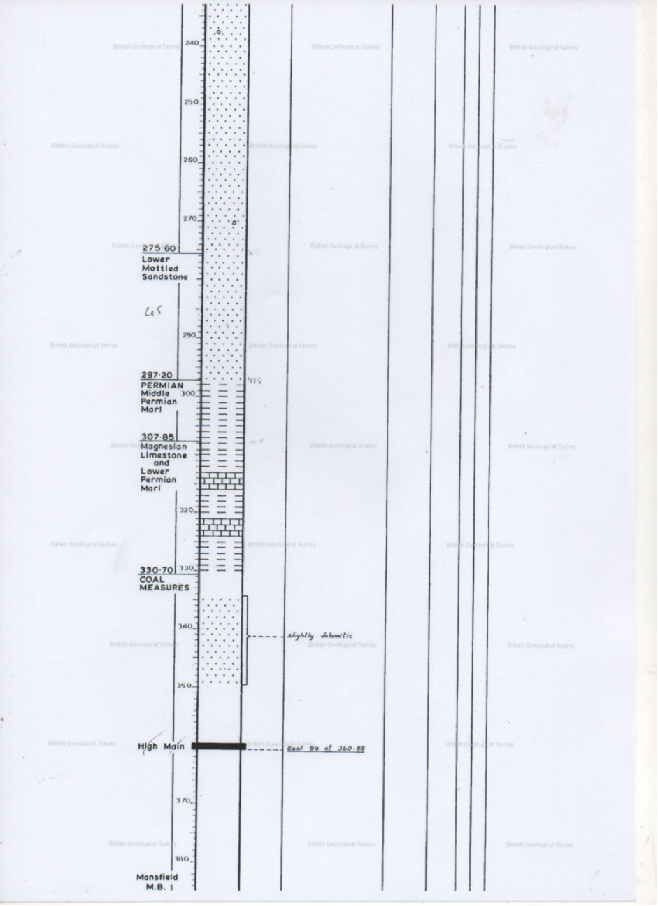
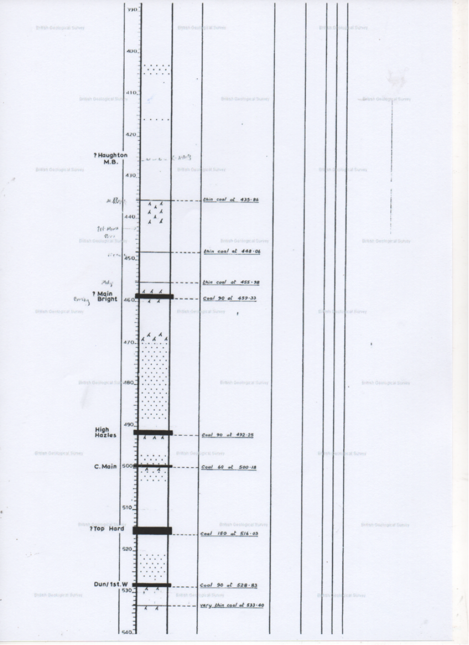
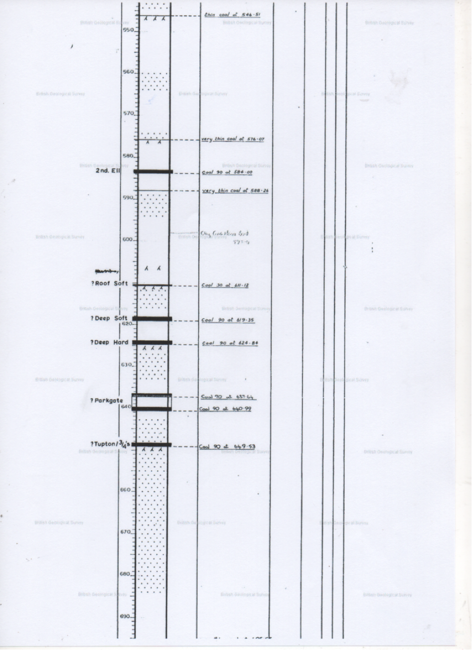
1.3.1 Screveton is a fortunate village in that it has the record of a deep borehole that was sunk in 1980. The purpose of which was for oil exploration. (The record of the strata passed through is attached as an appendix (1) to this report.)
1.3.2 The strata beneath the surface soils comprising of sediment/sand and glacial till are predominantly Keuper marl to a depth of 164 metres where it meets the Bunter or Sherwood sandstone. This formation is over 100 metres thick and overlies Permian marl and limestones which themselves overlie the coal measures that are over 700 metres thick with occasional Dolerite partings at depth. Beneath which lies an unproven thickness of Carboniferous limestone.
1.3.3 The main strata that lie beneath the target area are the marls which consist of clays with partings of sandstone, gypsum and gravels. The predominant mineral being thin gypsum deposits; north east around Newark where the beds are much thicker with minor extraneous materials, mainly marl and waterstones, these gypsum beds are around 60 feet thick, whilst at Screveton they are only inches in depth.
1.3.4 The marl is in itself a poor aquifer being predominantly made up of impermeable clays; fortunately for well development the marls are cut through with thin permeable layers, sandstone/waterstones and gypsum that provided the well water feeds.
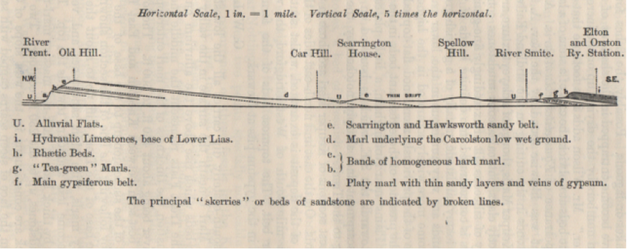
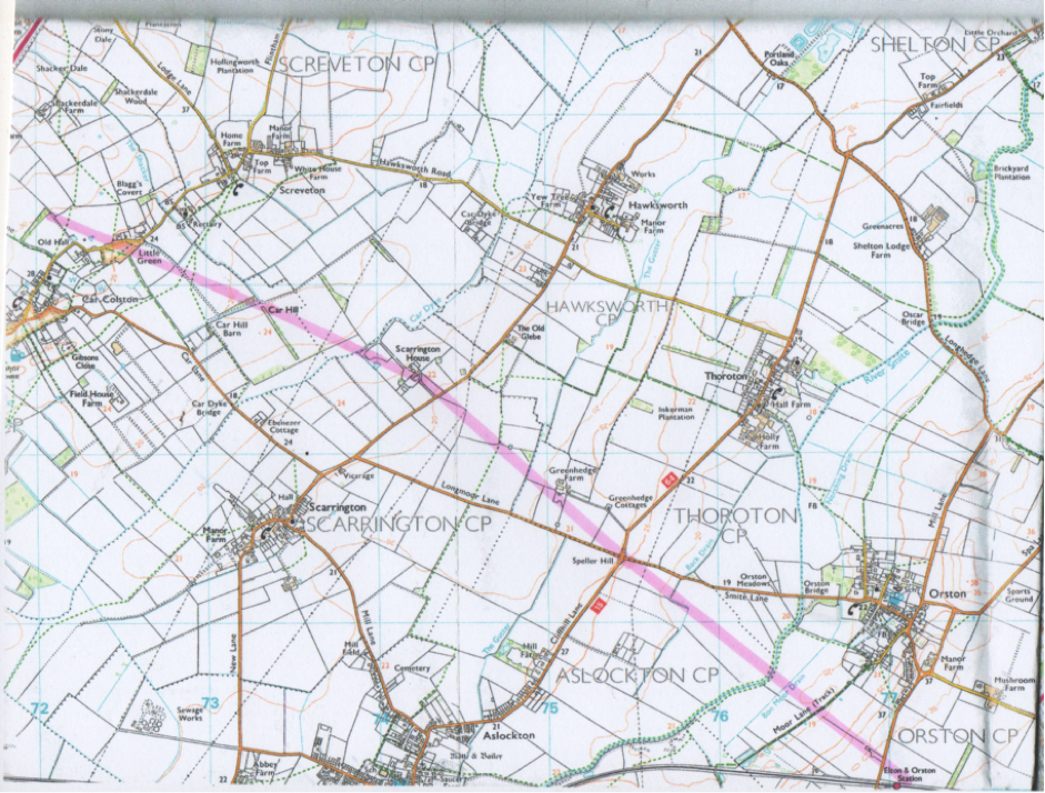
Fig.6 Section from the River Trent to Elton and Orston Station, demonstrating the strata at the southern edge of Screveton. See appendix 3. Car Hill being at the south west edge of the study area.
(From the geological memoir The Country between Newark and Nottingham 1908)
1.3.5 The geology of the area is not that of a productive aquifer; in the investergations garied out and reported prior to the First World War the yield of wells was noted as providing moderate supplies. The marl that overlies the area to some depth is only able to supply the household wells due to the presence of thin band of waterstones.
1.4 Past Exploration.
Over the past 150 years at least there have been active periods of exploration in the area looking at possible reserves of economic minerals, either during periods of national crisis such as during the 1st World War or in times of industrial need (1890-1913). After the 2nd World War the economic development of minerals continued and carries on to this day.
1.4.1 Coal.
1.4.1.1 Nottinghamshire was a coal producing county for many hundreds of years but none was won in this area. The nearest coal to be worked was from Cotgrave whose workings reached just to the West of Bingham and to the north of the same town from Gedling. The major coal seams do exist below the village at depth (see the borehole record at the end of this report) though in this area they are of thinner section due to less deposition of carboniferous material during the formation of the coal measures.
1.4.1.2 The coal seams beneath Screveton are shallowly dipping towards the south and east and might be considered as a possible source of energy from at least two methods. These are;
- Burning coal in situ with the heat generated driving generating engines such as was trialled during the Teruel Project in Northern Spain (1996-98), Derbyshire (1953-5) and the old USSR and now continues in the Russian Republic (since 1947).
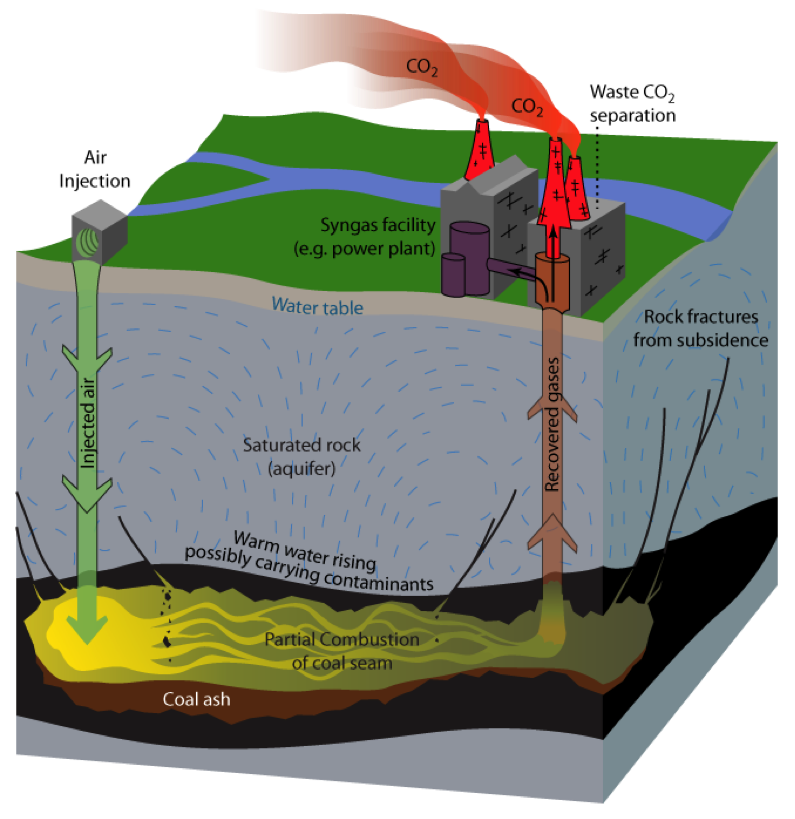
Fig 7. Underground Coal Gasification.Farming methane from the coal seams by fracturing. This has been carried out in the USA, Russia and China. The methods may include fracturing the coal seams using water and possibly a chemical mixture to maximise the methane flow from the extant coal seams. These techniques have been used and adapted for the generation of shale gas. (Fig 8.)
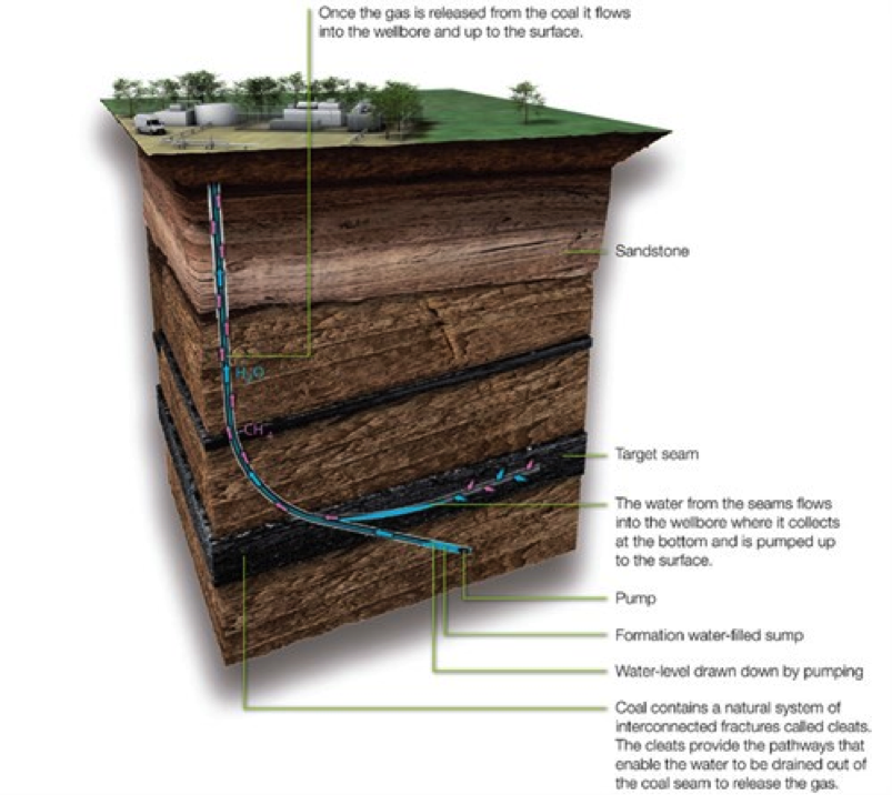
Fig 8
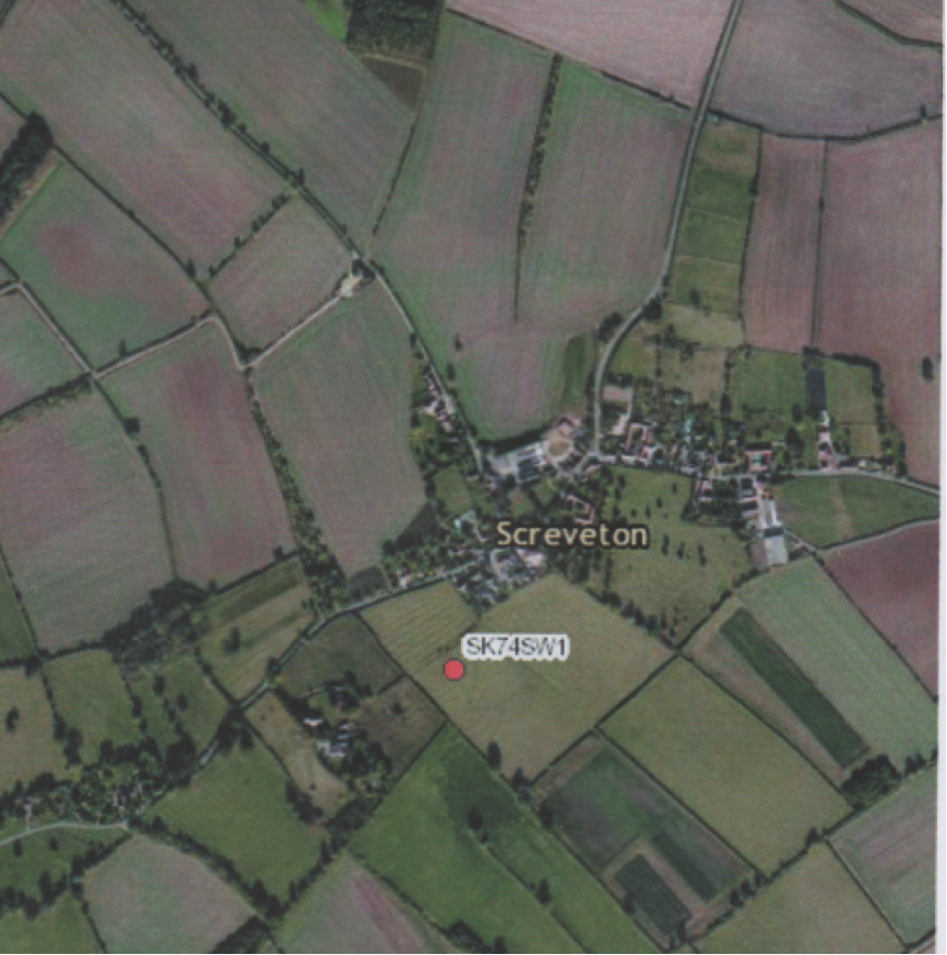
Fig 9.
1.4.2.1 The oil exploration borehole sunk in 1980; its location is shown on the above British Geological Survey photograph marked as SK74SW1 (Fig 9). The targeted oil horizons that were hoped to be proved were those at depths similar to those deposits found and developed at Eakring and Kelham Hills. The borehole, though finding traces of hydrocarbon found no oil as conventional deposits at the expected horizons. (Borehole log; Appendix 1.)
1.4.3 Shale Gas and Oil.
1.4.3.1 British Geological Survey has reported in 2013 that the region in which Screveton is located is suitable for further prospecting at depth due to the geological sequence known from the oil exploration borehole. It is likely that any future exploration would need to bore deeper than the depth of the oil exploration borehole of 1103.68 metres.
1.4.3.2 The prospects of finding suitable reserves of gas within the area are at present unknown till exploratory borings are placed. The use of any abandoned borehole from exploration might be of interest with regard to low temperature water infiltration utilisation.
1.4.4 Gypsum.
Gypsum was actively mined from the 1600s to 1940 around East Bridgford by both small open pit and drift mines. Exploration looked as far as Flintham but the settles to the south and east of Newark.
1.4.4 Past Water Supply.
1.4.4.1 The 1914 geological memoir of water sources in Nottinghamshire states the area is an ‘alluvial hollow’ in the marl drained by the Car Dyke,. It reports that there are many springs from the Keuper and the depression (land towards the Car Dyke) is waterlogged at a few feet beneath the surface, but the water quality is poor. Most of the wells are quite shallow, as the gypsiferous deeper sources are avoided. The well at the hall is 32 feet deep and carries 10-15 feet of water of a very hard quality. The average depth of wells in the village is 25 feet and the supply fairly abundant. A short way south of the village at Hawksworth the wells are much shallower due to an isolated soft skerry band that crops out to the west of the village.
1.4.4.2 A section of a well sunk at Car Colston towards Screveton;
Marl —————————————————————–11 feet
Skerry —————————————————————– 1 feet
Marl ——————————————————————- 6 feet
Hard beds with 2-3 inch vein of fibrous gypsum 2 feet
Total depth 20 feet
All this stratification is within the Keuper Marl.
1.4.4.3 The hard water was a perennial issue in homes and a domestic concern due to soap not lathering and the inability to scour cloths clean using the well supplies. Many houses either collected rainfall in butts or in drainage cisterns from their roofs for the washing of cloths.
2 Water Assets or Lack Of Them.
2.1 The area of the Parish of Screveton has several small watercourses that run mainly around the periphery of the village are large drain or dike. There are no natural lake or ponds of any size.
2.2 there are no extractive industries that have operated beneath the village. This negates the possibility of using water from flooded abandoned mines.
2.3 There has been talk that at least one farm reservoir IS being considered for development to collect rainwater for agricultural uses; this potential resource might have some value with regard to low temperature energy production but would be reliant on the design of such a facility.
2.4 The deep borehole that was sunk in 1980 was unlikely to have been filled and may have been capped off. This borehole would have filled with water and may have a caperbility to supply heated water from depth.
3 Discussion.
3.1 Coal is a possible location of energy by unconventional means; either burning the seam in situ or by coal seam methane drainage. Both are known technologies but may be discarded as unsuitable for the purpose of this study due to them being not low carbon or carbon neutral sources.
3.2 The use of low grade heat from flooded coal workings is not an option due to the distance of the research site from worked coal seams. (4.1)
3.3 The water courses are of little immediate value with regard to energy potential; they have no recorded use in driving water mills.
3.4 The borehole of 1980 may be a resource but its location may in all likelihood be in the wrong location, see fig 9.
3.5 The local wells are unlikely to be able to supply energy needs even for a proportion of the whole village envelope though there may be potential to develop individual dwellings energy needs of isolated farmsteads on the periphery of the parish.
3.6 A possible scheme may warrant research into viability of a spring source on the north eastern fringe of the village that could have its waters moved across the parish to be used as an agricultural reservoir and possible energy resource. At present the scheme would appear to be in need of a full viability appraisal and environmental study.
4 0ptions.
The purpose of this report was to consider the options that might be available to the village of Screveton in using any available water as a source of energy.
4.1 The potential of a reservoir to be both a water collection and storage facility and a low temperature heat source may be feasible. To create such a facility a design would need to look at a small water surface area but a depth of water that can be developed into a heat storage facility. Such a solution may be a depository for waste heat from other nearby facilities such as cooling units.
4.2 Explore condition of the 1980 borehole; both its location potential and physical condition.
4.3 Research any extant wells within the parish to ascertain any heat potential and possible pumping rates that might be sustainable.
Link to Screveton project;
www.eco-centre.org.uk/screveton-community-energy-project/
Bibliography.
Lamplugh GW, Gibson W, Sherlock RL, and Wright WB, 1908. The Geology of the Country between Newark and Nottingham. HMSO, London.
Guilford EL, 1912. Memorials of Old Nottinghamshire. George Allen, London.
Lamplugh GW, 1914. The Water Supply of Nottinghamshire from Underground Sources. HMSO, London.
Kelly AL, 1928. Kelly’s Directory of Nottinghamshire. Kelly’s Directories, London.
Edwards W (Editor), 1951. The Concealed Coalfield of Yorkshire and Nottinghamshire. HMSO, London.
Howitt RCL & Howitt BM, 1963. A Flora of Nottinghamshire. Privately Published.
Edwards KC (Editor), 1966. Nottingham and its Region. British Association for the Advancement of Science, London.
Anon 1970. The Hydrogeology of the Trent River Basin. Natural Environment Research Council, London.
Marquiss R (Editor), 1987. The Nature of Nottinghamshire. The Nottinghamshire Trust For Nature Conservation/Barracuda Books, Buckingham.
Charsley TJ, Rathbone PA and Low DJ, 1990. Nottingham: A geological background for planning and development. British Geological Survey, Keyworth.
Anon, 2003. OnTrent Pack. Derbyshire Wildlife Trust, Belper.
Jones NS, et al, 2004. UK Coal Resources for New Exploration Technologies Final Report. British Geological Survey, Keyworth.
Jones NS, Norton GE and Royles CP, 2005. A Guide to the Construction of the DGSM Nottingham Melton Lithoframe 250K Model. British Geological Survey, Keyworth.
Appendices.
1 the Screveton Borehole Record
Appendix 2
Licensed Water Abstractions in the Area.
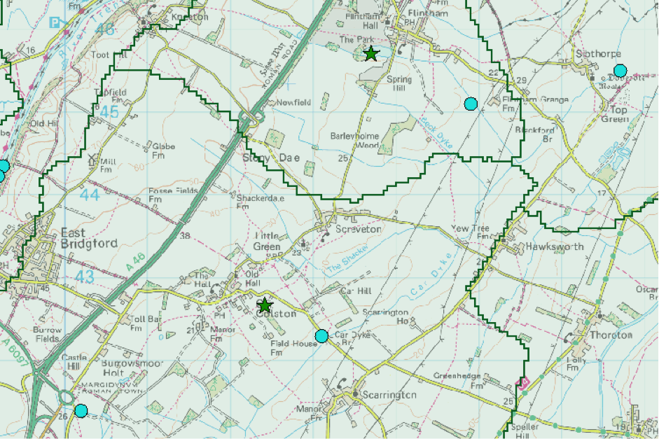
© Environment Agency 2014.
Appendix 3
Section Path.
Ordnance Survey/British Geological Survey.